Auchterderran Parish
Information specific to this area can be found below and on the left menu bar. We also recommend consulting the many general pages for information of general relevance to miners' lives. Please also see the following pages for information of direct relevance to this area
Derivations of names:
Auchterderran - from Gaelic Uachdar-doirean, top of the grove (oak); high land of the oak copse or groves
Bowhill - from Gaelic Buachille, buhill, boghel, herd
Carden - from Gaelic Car, winding; kar or cathair-dion, fort of shelter
Dundonald from Gaelic Dun, hill
The name Lochgelly is supposedly derived from the Gaelic Loch-gile meaning loch of brightness; clear; white. The loch was once well known for leeches. Up to mid 19th century Lochgelly was market town for Auchterderran, Ballingry and Beath parishes. The town is built on a hill with a ridge 600ft above sea level separating it from the loch. The principal superior is the Earl of Minto with some of the town actually in Ballingry parish owned by the Earl of Zetland.
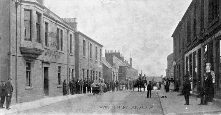 | 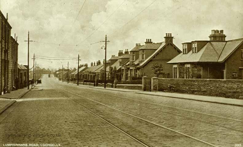 | ||||
Lochgelly, 1900s | Lumphinnans Rd, Lochgelly | ||||
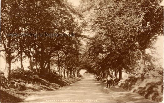 | 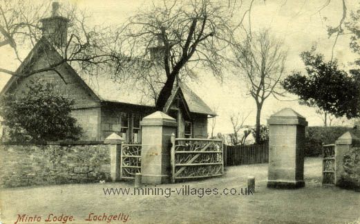 | ||||
Auchterderran Road Avenue | Minto Lodge, Lochgelly | ||||
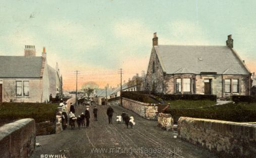 | 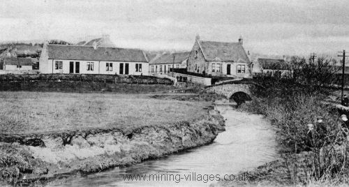 | ||||
Bowhill c1918 | | Orrbank, Cardenden c1904 | |||
 | 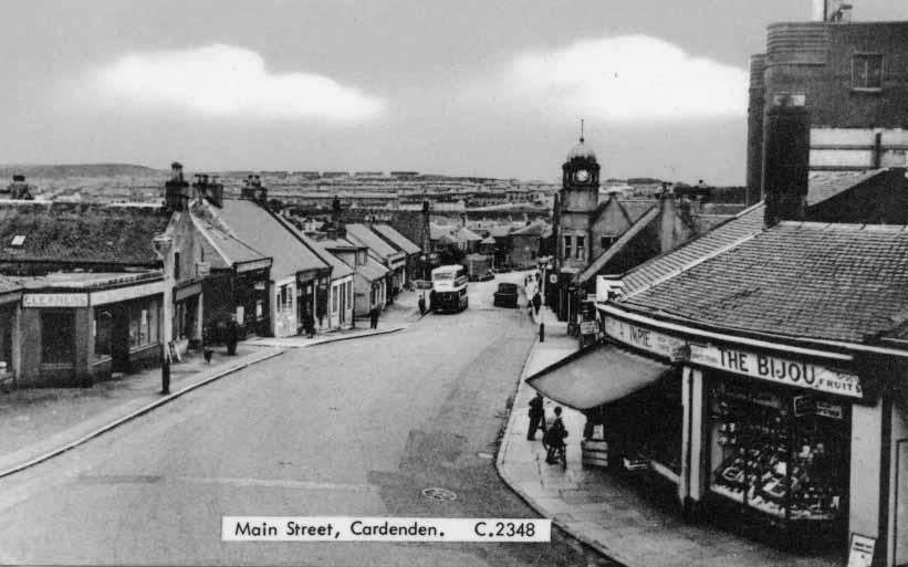 | ||||
Dundonald Park, Cardenden | Main Street, Cardenden | ||||
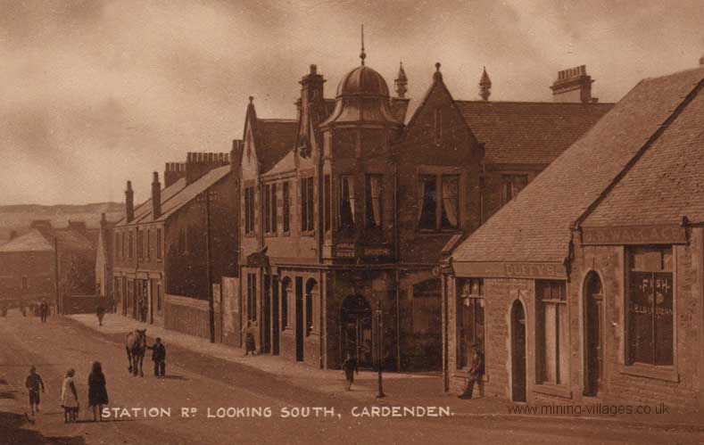 | 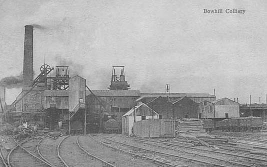 | ||||
Station Road, Cardenden c1921 | Bowhill Colliery c1915 | ||||
 | 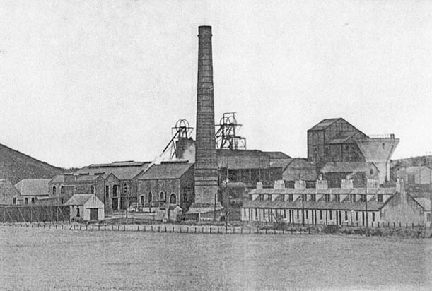 | ||||
Bowhill Colliery | Kinglassie Colliery |
Bowhill Colliery Memorial
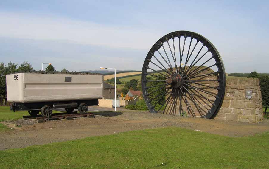 | Inscription reads: Lady Josephine Colliery Bowhill 1895 to 1965 Over 300 perished "Lest we forget" Erected 1996 Truck is inscribed "To commemorate all who passed through the gates of Bowhill Colliery 1895 - 1965 |
Ordnance Gazetteer of Scotland, Francis H. Groome, 1885
Lochgelly, a police burgh in Auchterderran parish, SW Fife. It stands 460 feet above sea level, 5 furlongs NW of Loch Gelly, and 3/4 mile S by E of Lochgelly Station on the Dunfermline branch of the North British Railway, this being 7 3/4 WSW of Thornton junction and 7 1/2 ENE of Dunfermline. The headquarters till 1798 of a gang of notorious gipsies, it dates mostly from modern times, and owes its paid rise to the extensive collieries and ironworks of the Lochgelly Coal & Iron Co (1850). It has a post office, with money order, savings' bank, and railway telegraph departments, an hotel, a police station, a public water supply (1880), a subscription library (1867), a floral and horticultural society (1871), a co-operative society (1866), a Good Templar's lodge (1871), a masonic lodge, a curling club (1831), and cattle fairs on the first Thursday of April o.s., the third Wednesday of July and September, and the first Thursday of November. The established church, built as a chapel of ease in 1855, in 1868 was raised to quoad sacra status. The Free Church was built about 1860; the U.P. church, which was long the only place of worship in the town, contains 400 sittings; and St Patrick's RC church (1877) contains 250. Two public schools, East and West, with respective accommodation for 390 and 310 children, had (1883) and average attendance of 367 and 294, and grants of £321, 2s. 6d. and £257, 5s. Loch Gelly, lying chiefly in Auchterderran parish, but partly in Auchtertool, measure 5 3/4 by 3 1/1 furlongs and is wooded and beautiful on its northern bank, but elsewhere bleak and tame. Lochgelly House, a seat of the Earl of Minto, stands near the NW corner of the lake and has pleasant grounds. The municipal voters numbered 300 in 1884 when the annual value of real property within the burgh amounted to £4290, whilst the revenue, including assessments is £480. Pop. of q.s. parish (1881) 3190 of which 605 were in Ballingry parish; of police burgh (1831) 612, (1861) 1629, (1871) 2496, (1881) 2601, of whom 117 were in Ballingry, and 1242 were females. Houses (1881) 500 inhabited, 98 vacant, 4 building. Ord. Sur., sh. 40, 1867.
Auchterderran, a hamlet and parish in SW Fife. The hamlet stand 3/4 mile N by W of Cardenden Station and 2 3/4 NE of Lochgelly, a town with a head post-office and another station lying within the western border of this parish. The latter is bounded N by Kinross shire and Kinglassie, E by Kinglassie and Dysart, SE by Kirkcaldy and Abbotshall, S by Auchtertool, SW by Beath and W by Ballingry. With a very irregular outline, resembling across, it has a length from East to W of 2 1/2 to 6 1/8 miles, a width from N to S of from 3 furlongs to 4 3/8 miles and an area of 7968 1/2 acres of which 150 1/4 are water. Loch Gelly (5 3/4 by 3 1/2 furlongs) lies on the Auctertool border and sends off a rivulet to the Ore, a sluggish stream, which winds through the middle of the parish from West to East along a low alluvial plain, traversed also by the Dunfermline branch of the North British Railway.
'Colquhally and the Sillertoun,
Pitcairn and Bowhill,
Should clear their haughs ere Lammas spates
The Ore bein to fill'
So the rhyme warns four farms in Auchterderran, and the warning is wholesome enough, since the Ore very readily overflows its banks. North and south of it hills rise to a height of 400 and 500 ft above sea level, points of elevation being Charleston (344ft), Harelaw (445), Auchterderran hamlet (287), Wester Colquhally (504), Lochgelly Huse (500) and Muirhead (437). The soil, mixed clay and sand, or black earth resting upon trap, is principally cold and stiff, yet there are large well cultivated farms, Dothan (424 acres) letting for £693 in 1875 whilst Balgreggie (130 acres) is all of it under grass.
Woods occupy some 520 acres; and the entire surface is parcelled out into arable and pasture lands, plantations, limestone quarries, coal and ironstone mines, thoroughfares, etc. The mining interest is very extensive; and seven collieries, belonging chiefly to the carboniferous limestone series, were at work here in 1879, that of Lochgelly being noteworthy for the great fire of 1870 - 71. A ruin, named Carden Tower, is the only antiquity. Four proprietors hold each an annual value of £500 and upwards, 13 of between £100 and £500, 7 of from £50 to £100 and 21 of from £20 to £50. For ecclesiastical and school board purposes, Auchterderran forms one quoad sacra parish, and Lochgelly another, both in the presbytery of Kirkcaldy and synod of Fife. The ancient church of Auchterderran was given by Fothad, last Bishop of Alban (1059 -93), to God, St Serf and the hermit Culdees of Lochleven; the present building was erected at the hamlet in 1789 and its ministers income if £463. The public school, with accommodation for 350 children, had (1879) and average attendance of 189, and a grant of £177, 10s. Valuation (1881) £19,294,10s. Pop of quoad sacra portion (1871) 1623, (1881) 1747; of entire parish (1811) 2403, (1841) 3352, (1871) 4017, (1881) 4332, of whom 2484 were in Lochgelly burgh.- Ord. Sur., sh. 40, 1867.
Cardenden, a glen and a village with a station in Auchterderran parish, SW Fife. The glen extends N and S; is about 1 mile long, wide, unwooded, and fertile; has rich substrata of coal; and is crossed at the N end, by the Thornton and Dunfermline branch of the North British Railway. The village with the station is there, 3/4 miles S by E of Auchterderran village, and 5 3/4 miles WSW of Thornton junction.
Cluny, a village in Auchterderran parish, Fife, 1 mile E of Cardenden station, and 4 miles NW of Kirkcaldy. Extensive collieries are in its eastern vicinity. [1895 edition]
Coalden, a collier village in Auchterderran parish, Fife, 1 1/2 mile E by N of Cardenden station, and 4 3/4 miles NNW of Kirkcaldy. [1895 edition]
A topographical dictionary of Scotland, Samuel Lewis, 1846
Lochgelly, a village, in the parish of Auchterderran, district of Kirkcaldy, county of Fife, 2 1/4 miles (ENE) from Beath; containing 612 inhabitants. This village is pleasantly situated in the south-west part of the parish, and near the loch from which it takes its name; the high grounds have an elevation of more than 300 feet above the level of the sea, and are cultivated to the very summit. The borders of the lake, which is three miles in circumference and in some parts of great depth, abound in richly-diversified scenery, comprising highly cultivated fields well inclosed, and numerous flourishing plantations. A subscription library is supported, and a savings' bank has been long established here. Many of the inhabitants are employed in the neighbouring collieries belonging to Lord Minto, and in the quarries. The road from Beath to Auchterderran passes close by the village. There is a place of worship for members of the United Secession ; also two schools attended by about seventy children each, and the masters of which are exclusively supported by the fees.
Auchterderran, a parish, in the district of Kirkcaldy, county of Fife, 6 miles (NW by W) from Kirkcaldy; containing 1913 inhabitants, of whom 770 are in the village of Lochgelly. This parish is about six miles in length, and three in breadth; the surface is mostly flat, though varying in elevation, the lands near Lochgelly being more than 100 feet above the general level. The river Ore, which has its source in the parish of Ballingry, flows through this parish, in its course to the Leven, and has two bridges, each of one arch; the scenery is greatly varied, in some parts dreary, and in others richly ornamented with plantations, especially near the lake of Lochgelly, a large sheet of water about three miles in circumference, the shores of which, sometimes wooded, have a beautiful appearance. The soil is chiefly clay, interspersed with sand, but in several places are tracts of black loam, producing abundant crops; about one-third of the land is in pasture, about 500 acres wood, and the remainder arable, in good cultivation. The system of husbandry has been greatly improved, under the auspices of the late Lord Minto and other of the landed proprietors; a considerable tract of waste was converted into rich arable land, by the late proprietor of Raith, and is now one of the most productive farms in the parish. The crops are, wheat, barley, oats, potatoes, beans, and peas; the cattle are of the black Fifeshire breed, and much attention is paid to their improvement; the farm-buildings are commodious, and the lands, which are well drained, are generally inclosed with stone dykes. The rateable annual value of the parish is £5018. There is very little natural wood, and the plantations are mostly of recent growth; about 15 Scotch acres of moss have been lately planted with Scotch firs, which are thriving well. The substratum is mainly whinstone; limestone of excellent quality is quarried in several places, and coal is every where abundant. The coal-mines at Cluny, belonging to Mr. Ferguson, are very productive; about 70,000 loads are annually raised, for the supply of the neighbourhood, and more than 70 persons are employed in the works. The mines on Lord Minto's lands of Lochgelly produce 50,000 loads annually, and afford constant occupation to about fifty persons; and the works at Dundonald, belonging to R. W. Ramsay, Esq., produce about 7000 loads. The parish is in the presbytery of Kirkcaldy and synod of Fife; the minister's stipend is £237 11s 10d, with a manse, and a glebe valued at £30 per annum; patrons, the Boswell family, of Balmuto. The church was built in 1789, and is situated near the east side of the parish. There is a place of worship for Seceders, in the village of Lochgelly. The parochial school is attended by nearly 100 scholars; the master has a salary of £34 4s 5d, with £25 fees, and a good house.